
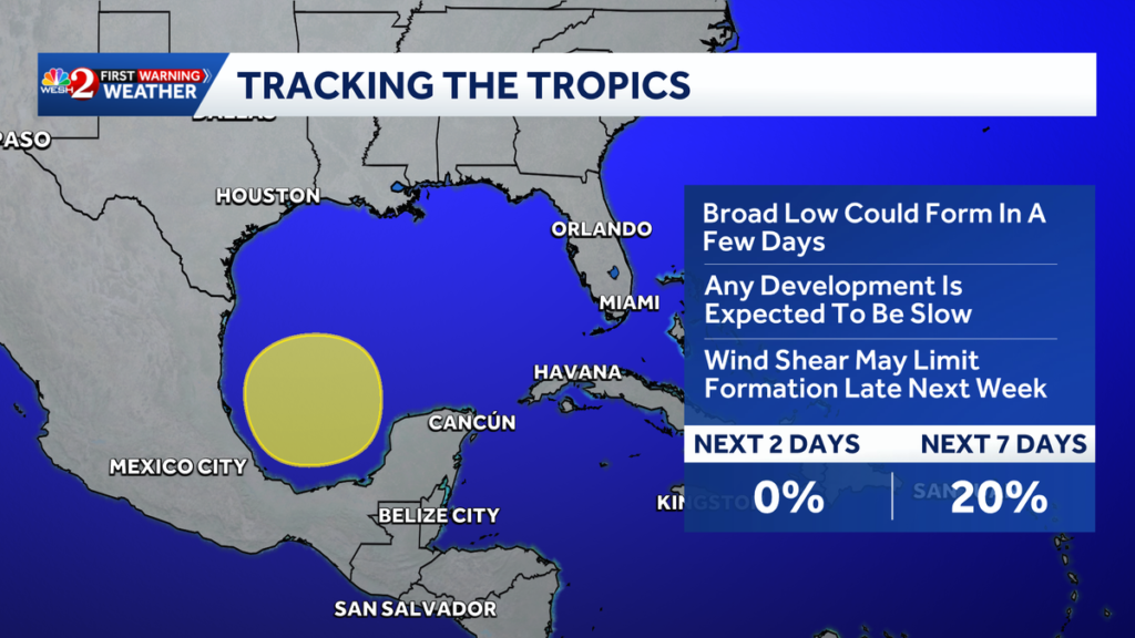
A developing area of unsettled weather in the Gulf of Mexico is being monitored by forecasters as meteorologists assess whether the system could become more organized later this week.
The National Hurricane Center is tracking the disturbance across the southwestern Gulf and Bay of Campeche. At this stage, the system remains broadly organized and has little immediate potential to become a tropical depression or storm. However, atmospheric conditions could change over the coming days, prompting forecasters to maintain close watch.
According to the latest outlook, the disturbance has almost no chance of tropical development during the next 48 hours. The probability increases over a longer period, reaching roughly 40% over seven days. The system therefore remains an area of interest rather than a developed tropical cyclone.
A broad area of low pressure is associated with the disturbance, and forecasters are examining whether it can gradually establish a more defined circulation. The system is expected to move slowly over Gulf waters while meteorologists monitor changes in its structure and surrounding environment.
Moisture is another factor attracting attention. Tropical moisture from the Caribbean is moving toward the Gulf, helping to fuel showers and thunderstorms across the region. Even if the disturbance does not become a named storm, this moisture could contribute to periods of heavy rain along portions of the Gulf Coast later in the week.
Computer forecast models are offering different possibilities for the system’s future. Some projections suggest the disturbance could become better organized near the Bay of Campeche before moving farther north, while other forecasts indicate that it may remain weak and eventually move inland.
Atmospheric wind patterns will also influence the system’s potential development. Increasing wind shear across parts of the northern Gulf later in the week could prevent the disturbance from strengthening significantly. Forecasters are weighing these conditions as they attempt to determine how much opportunity the system has to organize.
For people living along the Gulf Coast, there is currently no indication of an immediate major threat. The disturbance remains several days away from any potential significant impacts, and considerable uncertainty remains regarding its eventual movement.
Rain could nevertheless become a more noticeable factor. Increasing tropical moisture may result in more clouds, showers and thunderstorms across portions of the southern United States later this week. Local rainfall could become heavy in some areas even if the disturbance never develops into a tropical cyclone.
The timing of the disturbance is also worth watching because tropical activity can continue in the Gulf during October. Although the peak of the Atlantic hurricane season has passed, warm Gulf waters and abundant moisture can still provide ingredients for tropical development when atmospheric conditions are supportive.
Forecasters will continue using satellite observations, weather models and other meteorological data to determine whether the system is becoming more organized. Changes in its circulation, rainfall and thunderstorm activity could lead to adjustments in the development forecast.
At present, the disturbance remains a relatively weak weather feature rather than a tropical storm or hurricane. Its very low short-term development potential means residents do not need to take immediate action based solely on the current outlook.
However, the higher probability over the seven-day period means the system will remain on the National Hurricane Center’s watch list. People along the Gulf Coast are encouraged to monitor official forecasts, particularly if the disturbance begins showing signs of stronger organization.
The system’s eventual outcome remains uncertain. It could weaken before becoming organized, or environmental conditions could allow it to gradually strengthen. Much will depend on wind shear, moisture, ocean temperatures and the direction of the disturbance over the next several days.
For now, meteorologists are continuing to observe the Gulf system closely. While there is no immediate tropical threat, the potential for gradual development later in the week means the disturbance will remain an important feature in the region’s weather forecast.
You can watch the video below