
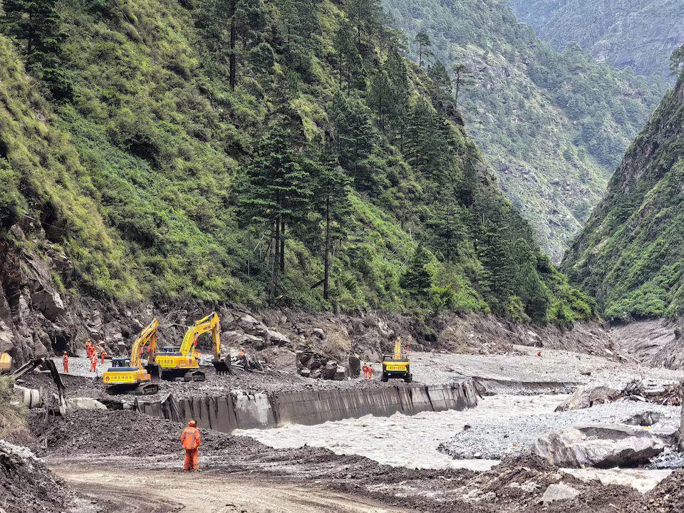
Chinese authorities are intensifying emergency measures after a newly created lake near the Nepal border raised concerns about the possibility of another dangerous flood in a region already affected by a major glacier-related disaster.
The lake developed after a large amount of landslide debris blocked a river close to the meeting point of Nepal’s Chhochen Khola and China’s Purepu Tsangpo River. Officials are closely watching the natural barrier because a sudden collapse could release a huge volume of water downstream.
The development follows a devastating debris flow and flash flood that recently struck mountainous communities on both sides of the border. The disaster sent water, mud, rocks and ice through valleys after a glacier collapse in Nepal. Preliminary analysis from the U.S. Geological Survey suggested that the event was likely connected to a glacial collapse in Langtang National Park.
Chinese authorities have responded by activating emergency flood measures and sending specialist teams into the affected area. Monitoring operations are being supported by satellite data, aerial observations and other technologies intended to track changes in the lake and the surrounding landscape.
Early estimates suggest the newly formed lake is around 150 metres in length and approximately 40 to 50 metres deep. Authorities estimate that it currently holds between 1.5 million and 2 million cubic metres of water. The volume could rise further if additional water continues to flow into the basin, potentially increasing pressure on the debris barrier.
One option being examined by engineers is the construction of a controlled drainage channel through a lower part of the natural dam. If considered safe, the method could gradually release some of the stored water and reduce the pressure on the barrier.
However, officials face difficult conditions in deciding how to proceed. Engineers must assess the stability of the surrounding terrain, determine the appropriate dimensions for a drainage route and calculate how quickly the lake could continue to fill.
The geography of the area presents another major obstacle. The original glacier collapse and landslide have created unstable slopes and steep cliffs around the lake. Rainfall could further weaken the terrain while increasing the amount of water entering the newly formed lake.
Authorities have therefore ordered continued surveillance of rainfall, water levels and movement around the natural dam. Officials are also assessing downstream areas that could potentially be affected should the barrier fail.
Emergency planners have been asked to strengthen warning systems and prepare evacuation arrangements where necessary. Such preparations are considered particularly important because the region is already dealing with extensive damage from the earlier flood.
Roads, bridges and other infrastructure have been damaged or destroyed, making transportation, rescue work and the delivery of assistance more challenging.
The latest incident has also renewed attention on the broader danger posed by glaciers and glacial lakes throughout the Himalayan region. Scientists have identified numerous lakes that could become hazardous if their natural barriers fail.
A 2026 study examining the China-Nepal Himalayas found thousands of glacial lakes across the region, including dozens considered potentially dangerous. These findings underscore the difficulties faced by communities living downstream of rapidly changing mountain environments.
A glacial lake outburst flood can occur when water suddenly escapes from a lake held behind a natural barrier made from glacier debris, rock or moraine. The resulting surge can move rapidly through narrow valleys, carrying large quantities of mud, rocks and other debris.
The immediate challenge for Chinese authorities is now to prevent another such event while recovery efforts from the previous disaster continue.
Specialists are gathering additional data and monitoring the lake as they assess whether intervention is necessary. Weather conditions will remain an important factor, particularly if further rainfall increases the lake’s water level.
For people living downstream, the situation remains closely monitored. Emergency officials are preparing for possible developments while engineers study ways to lower the potential danger without destabilising the surrounding terrain.
The priority is to detect any signs of movement or rapid water-level changes early enough to issue warnings and protect communities. With the natural barrier still under scrutiny, authorities remain focused on reducing the possibility of another destructive flood in an already severely affected part of the Himalayas.